


January 1, 2012: What better way to celebrate the New Year than to take a drive around your neighborhood, just to enjoy the diversity and natural beauty of the area in which you live. I drove a total of thirty one miles round trip, taking a little over two hours to complete the journey. During my "Photo Trek", I had the fortunate opportunity to view eighteen (18) Moose. The highlight was having the chance to see three Bull Moose with the remainder being Cows and Calves. This is the highest Bull to Cow ratio that I have witnessed in recent years.
My trip started just a mile from my home on the beaches of Cook Inlet in Anchor Point, Alaska. The temperature was a balmy -9 degrees. This is the most Westerly Highway Point in North America that is continuously connected by the highway system. Cook Inlet is named after the famed British Explorer, Captain Cook. Unusual to see the air temperature low enough in comparison to the salt water temperature to create steam.
"Cook Inlet New Year's Day 2012"

Approximately fourteen miles inland from the beaches of Cook Inlet. This location is relatively close to where my wife's family homestead in the 1950's. The valley in the foreground is the Anchor River Valley. The plateau shape mountain in the background is Ohlson Mountain. In the 1950's to 1963 this was an active Air Force Base for communications and connected in with the Dew Line and White Alice Sites. All of which were early warning systems for our National Defense. Temperature at this location is -14.
"Anchor River Valley and Ohlson Mountain"

From this particular site, you can also see the mountains that border Kachemak Bay which flows into Cook Inlet. The distance to those mountains is deceiving. They are approximately 30 - 35 miles in distance from where this photo was taken. To reach those mountains from this point by cutting across country, you would need to traverse several smaller ridges and valleys as well the Anchor River Valley, Crossman Ridge, and Diamond Ridge; eventually dropping down onto the bench where the City of Homer is located on the north shoreline of Kachemak Bay. From Homer, you would then need to cross Kachemak Bay to reach the lower slopes of this mountain range. The area in which this picture was taken was homesteaded by hardy families, prior to the construction of any road system. One of their primary access trails into this area was from Diamond Ridge. Which is the last tree line ridge you can see in the photo.
"Upper Anchor River Valley"

With a recent heavy snowfall, the Moose are now moving from the higher elevations of the foothills into the lower elevations to winter. These low lying valleys and ridges are their winter habitat areas primarily due to less snow accumulation and the willow patches that provide them their food source. The cows will remain in the area until the spring calving season before moving back into the foothills.
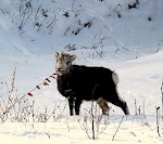
"Young Bull Moose Feeding On Willows On the Banks Of The Anchor River"

Looking at the immense size of a mature moose, one would think that they would be easy enough to spot. It would be surprising to know the number of people and cars that Moose see, yet those same cars and people never see the Moose. This particular Cow and I had some fun playing, "Peek A Boo", I spent a half hour with her, just to watch her reaction. She would move out of my sight behind a tree, then peek out to see what I was doing. I would move, she would move, and take a peek.
"Peeking Through The Snow Laden Spruce Boughs"

"Cow Moose In Hiding"

My New Year's trip concluded at my starting point, just in time to watch the sun slip below the horizon. The active volcano, St. Augustine across Cook Inlet highlighted in the setting sun, a fitting way to close out the daylight hours of the first day of the New Year.
Now, ask me again, Why do you live in Alaska?
"Saint Augustine at Sunset"


No comments:
Post a Comment